Discovering Cities Workshop | Amman

Discovering Cities Workshop | Amman

Hosted by: German Jordanian University, SABE (Amman, Jordan)
Funded by: DAAD

Locating and dimensioning spatial objects and with it the creation of spaces is at the heart of urban design. Thereby it is necessary to precast the effects that design decisions have on the behavior of the future users as well as to estimate the sustainability and resilience of the city. Computational analysis methods can help to support this process due to the fact that they can reveal properties that are hardly recognizable at first intuitive sight.

This workshop is a part of 10 days excursion in the city of Amman, Jordan. It will be the final stage of a seminar to learn and apply methods for the quantitative analysis of urban space (such as density, accessibility, visibility) and examine in how far these quantities relate to real life phenomena such as the spatial configuration of economical activities in a city or the movement patterns of urban users.

The seminar is part of an ongoing DAAD-funded project on discovering urban social and spatial patterns of Islamic cities and fostering exchange between German and Jordan academics in the field of urban planning.

Presentation

Workshop files

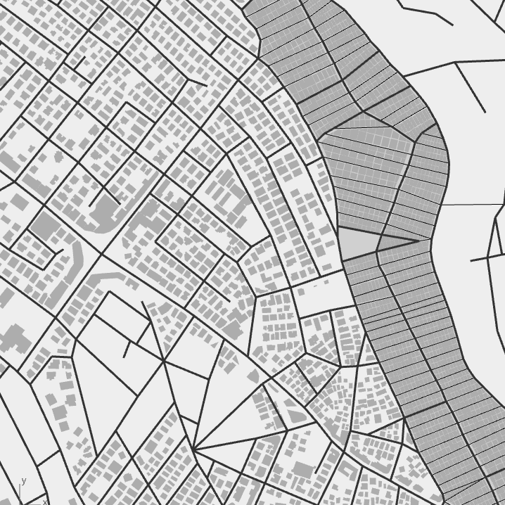
Jabal Al Hussain | model

Simplified street network and building footprints for Jabal Al Husain neighborhood.

Layers:

Palestinian refugee camp

  • Pedestrian street network
  • Car street network
  • Building footprints

Jordanian old district

  • Pedestrian street network
  • Car street network
  • Building footprints

Download Rhino file

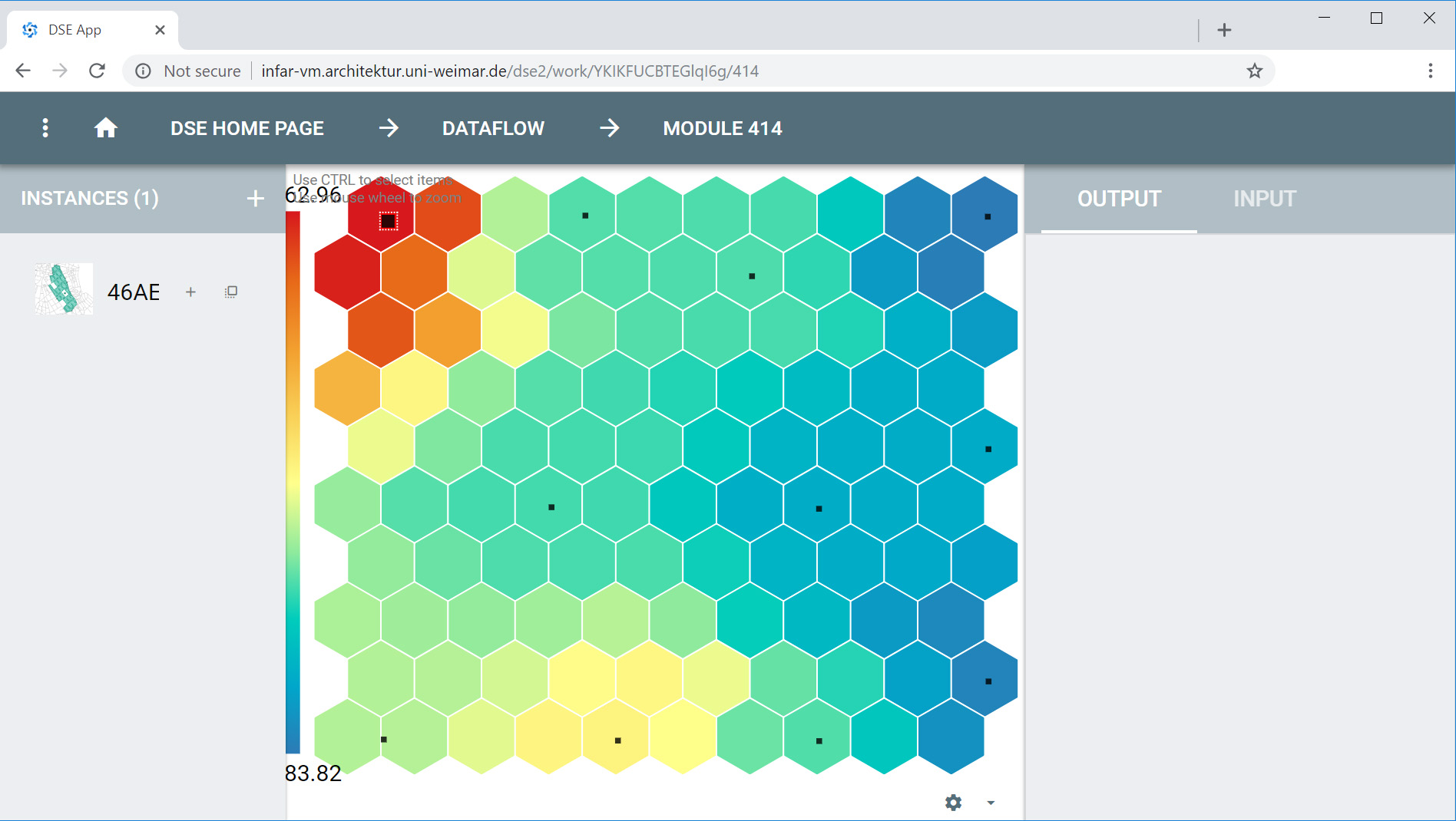
Building coverage Density | script

Building coverage density is a measure of the relationship between built area (B) and area of the plan (A). It identifies how developed an area is along a scale of zero (no development) to one (the whole area is occupied by buildings).

This script measures the distribution of building coverage density through out the space and map the results on a grid. The plan area (A) in this script is defined as circular radius with flexible diameter parameter. The setting of the diameter influence if the density captures just close surrounding area of given location or larger neighborhood.


Download Grasshopper file

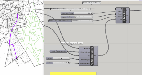
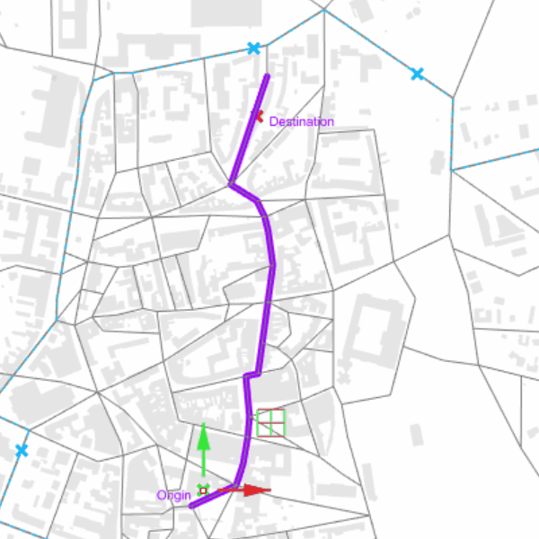
Street Network Centrality | script

Centrality measures for the street network in pedestrian radius of 600m and global car radius Rn. The analysis is calculated for Jordanian neighborhood alone and combined with the refugee camp

Centrality measures:

  • Closeness (integration) R600, Rn
  • Betweenness (choice) R600, Rn

Download Grasshopper file

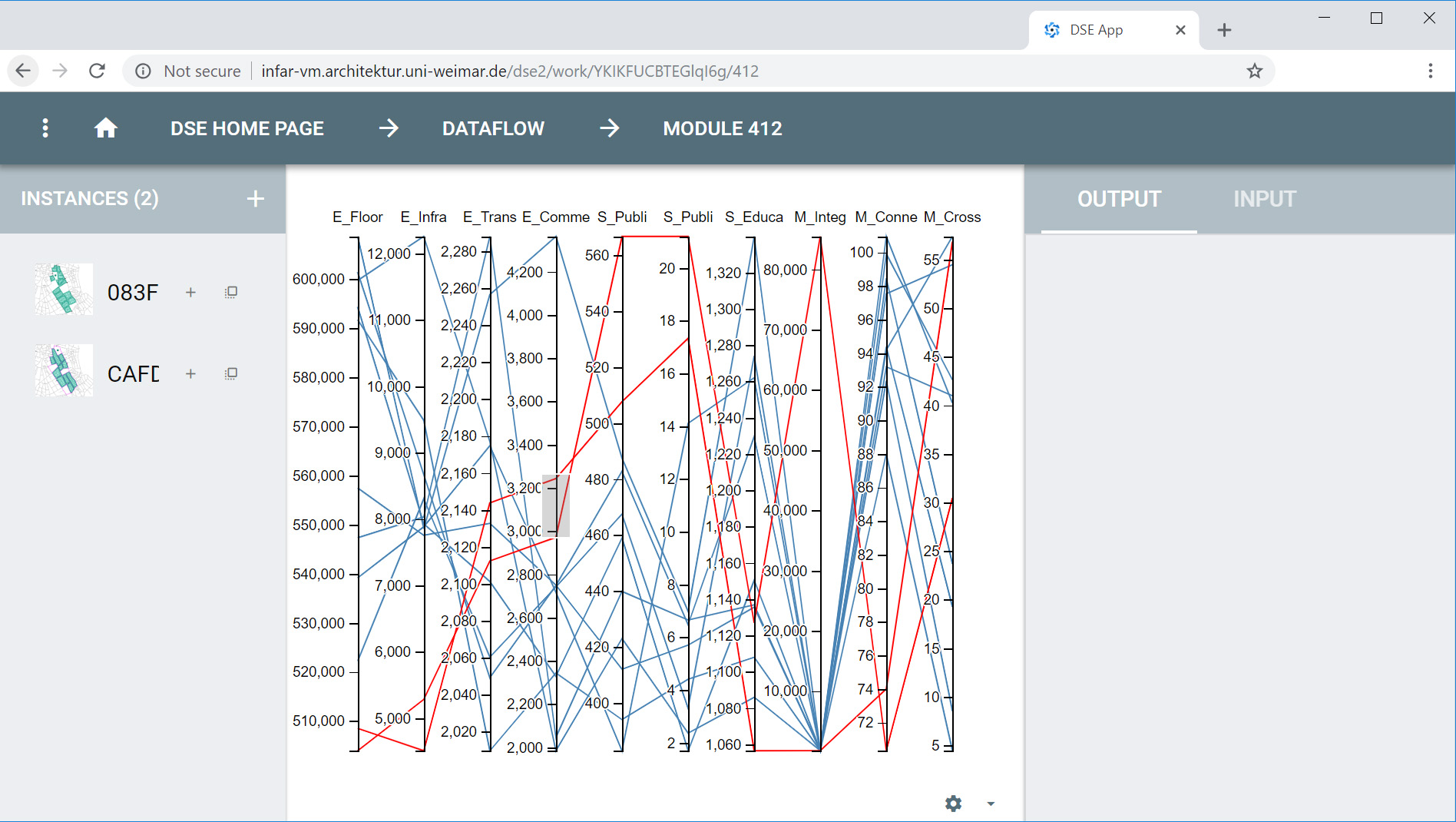
Behaviour vs. Centrality | script

In this script you can link the empirical countings to the street network centrality and visualize the relationship between those two variables.The strong relationship suggest that the countings are influenced by the street network configuration. if not, they are independent.


Download Grasshopper file

eCAADe2018 Workshop | Urban Analysis, Synthesis and Exploration with Grasshopper

eCAADe2018 Workshop | Urban Analysis, Synthesis and Exploration with Grasshopper

DeCodingSpaces workshop on Urban Analysis, Synthesis and Design Exploration in Grasshopper hosted by: eCAADe2018, Poland – Łódź, 18.September 2018

In this workshop, you will learn how to generate urban fabric variants, perform quantitative analysis on it, as well as optimize the generated variants and expore the cooresponding solution space. For this purpose you will be introduced to various components from the DeCodingSpaces Toolbox for Rhino/GH. You will learn how to analyse Street Networks effectively to compute real life phenomena such as the distribution of functions in a city or the movement patterns of citizens. Moreover, you will be introduced to the various methods for the synthesis of urban morphology (street networks, plots, and buildings) and how they connect to the analysis methods. Finally, you will also be introduced to design space exploration tool for beeing able to compare the generated solution systematically. The presented DeCodingSpaces-Toolbox for Grasshopper is a collection of analytical and generative components for algorithmic architectural and urban planning. The toolbox is free software released by the Computational Planning Group (CPlan). It integrates established urban analysis methods, extends them with new features and introduces new methods for the analysis and synthesis of urban morphology. In the first part of the workshop, you will learn to use the street network analysis components and how the computed quantities relate to real life phenomena such as the distribution of functions in a city or the movement patterns of citizens. In the second part, we will implement a dynamic urban simulation in Grasshopper. For this purpose, we will use the results from the network analysis and compute local attractivity values for different urban functions like the population or workplaces, which interact with each other based on the corresponding distances. In the third part, we will demonstrate functions of the DeCodingSpaces-Toolbox for the synthesis of urban morphology (street networks, plots, and buildings), which is directly connected to the analysis and the simulation parts. In the last part, we use a Design-Space-Exploration tool (DSE) that presents the generated solutions in various ways.

Presentation
<iframe src="https://onedrive.live.com/embed?cid=C274443D8FC8835F&resid=C274443D8FC8835F%21247480&authkey=AKMlk2xrQcJQC0k&em=2" width="800" height="440" frameborder="0" scrolling="no"></iframe>
Workshop files

Part 1 – Analysis

Isovist

<iframe src="https://onedrive.live.com/embed?cid=C274443D8FC8835F&resid=C274443D8FC8835F%21247836&authkey=ADx2hkUcalVCm6c&em=2" width="800" height="460" frameborder="0" scrolling="no"></iframe>

01| 2D ISOVIST SINGLE POINT

Analysis 2d, 3d Isovist


Download Grasshopper file

04| 2D ISOVIST OBJECT VISIBILITY

Analysis 2d, 3d Isovist


Download Grasshopper file

02| 2D ISOVIST PATH

Analysis 2d, 3d Isovist


Download Grasshopper file

05| 3D ISOVIST

Analysis 2d, 3d Isovist


Download Grasshopper file

03| 2D ISOVIST FIELD

Analysis 2d, 3d Isovist


Download Grasshopper file

Street Network Analysis

01| CITY GRAPH STARTING EXAMPLE

Street Network Analysis


Download Grasshopper file

04| CITY GRAPH ONE WAY ROADS

Street Network Analysis


Download Grasshopper file

02| PARK EDGE WEIGHTING

Street Network Analysis


Download Grasshopper file

05| CITY GRAPH CENTRALITY VERTEX WEIGHTING

Street Network Analysis


Download Grasshopper file

03| CITY GRAPH BUS EDGE WEIGHTING

Utilities

01| NETWORK EDITING TOOLS

02| ANALYSIS GRID

03| CUSTOM OFFSET

Part 2 – Generation

<iframe src="https://onedrive.live.com/embed?cid=C274443D8FC8835F&resid=C274443D8FC8835F%21247834&authkey=AMysWlAm22Zf6x8&em=2" width="800" height="460" frameborder="0" scrolling="no"></iframe>

01| STREET NETWORK FROM GUIDE LINE

02| STREET NETWORK FROM GRID

03| STREET NETWORK SYNTHESIS

Part 3 – Exploration

<iframe src="https://onedrive.live.com/embed?cid=C274443D8FC8835F&resid=C274443D8FC8835F%21247833&authkey=AJxEsDfWKclD3Gk&em=2" width="800" height="460" frameborder="0" scrolling="no"></iframe>

01| DESIGN SPACE EXPLORATION

Part 4 – Hands On, Generate Analyze & Explore

<iframe src="https://onedrive.live.com/embed?cid=C274443D8FC8835F&resid=C274443D8FC8835F%21247689&authkey=AEgk0zw0HI9JXqo&em=2" width="800" height="460" frameborder="0" scrolling="no"></iframe>

Weimar Urban Layout Generator

Impressions of the Workshop Results

http://infar-vm.architektur.uni-weimar.de/dse2/dse
The session ID is: YKIKFUCBTEGlqI6g

Workshop | Network analysis based dynamic urban simulation in Grasshopper

Workshop | Network analysis based dynamic urban simulation in Grasshopper

DeCodingSpaces workshop on network analysis based dynamic urban simulation in Grasshopper hosted by: SimAUD 2018, Netherlands, TU Delft, 04.Jun 2018

After a general introduction to spatial analysis methods, you learn in this workshop how to use components from the DeCodingSpaces-Toolkit in Rhino/GH for the quantitative analysis of urban space. Based on these analyses we implement a basic urban development simulation for a case study city. The presented DeCodingSpaces-Toolbox for Grasshopper is a collection of analytical and generative components for algorithmic architectural and urban planning. The toolbox is free software released by the Computational Planning Group (CPlan). It integrates established urban analysis methods, extend them with new features and introduces new methods for the analysis and synthesis of urban morphology.

Presentation
Workshop files
Part 1

01| 2D ISOVIST SINGLE POINT

Analysis 2d, 3d Isovist


Download Grasshopper file

03| 2D ISOVIST FIELD

Analysis 2d, 3d Isovist


Download Grasshopper file

05| 3D ISOVIST

Analysis 2d, 3d Isovist


Download Grasshopper file

02| 2D ISOVIST PATH

Analysis 2d, 3d Isovist


Download Grasshopper file

04| 2D ISOVIST OBJECT VISIBILITY

Analysis 2d, 3d Isovist


Download Grasshopper file

Part 2

01| CITY GRAPH STARTING EXAMPLE

Analysis Street Network


Download Grasshopper file

03| CITY GRAPH BUS EDGE WEIGHTING

02| PARK EDGE WEIGHTING

Analysis Street Network


Download Grasshopper file

04| CITY GRAPH ONE WAY ROADS

Analysis Street Network


Download Grasshopper file

04| CITY GRAPH CENTRALITY VERTEX WEIGHTING

Analysis Street Network


Download Grasshopper file

Part 3

01| NETWORK EDITING TOOLS

03| CUSTOM OFFSET

02| ANALYSIS GRID

Part 4

01| DYNAMIC URBAN DEVELOPMENT MODEL

02| More Information

Please find more detailed information in the related paper on Urban Simulation with Grasshopper for Rhino3D.


Pin It on Pinterest