
The presented study is made for Cape Town city in South Africa, in which approximately 7.5 million people living in informal settlements and about 2.5 million housing units are needed. This motivates us to develop upgrading strategies for informal settlements. For this purpose, we developed an adaptive and interactive tool for rapid computational urban design prototyping. The tool can be used to generate urban layouts including street networks, blocks, parcels and buildings based on requirements specified by an urban designer. For implementing the layout generation process, we developed an underlying tree data structure to represent street networks and parcellings. Moreover, network analysis methods were applied for controlling the distribution of buildings in the communities so that preferred neighborhood relationships are considered. Finally we demonstrated how to compare designs based on spatial analysis.
Research Team: Reinhard Koenig (contact author), Peter Bus, Yufan Miao, Chang-Mei Chih, Artem Chirkin.
The presented research evolves within the context of a collaboration with Scott Lloyd from the Urban Think Tank (U-TT) at ETH Zurich.
Acknowledgement
This page contains accompanying material for the paper Computational Urban Design Prototyping: Interactive Planning Synthesis Methods Demonstrated by a Case Study in Cape Town, published in the International Journal of Architectural Computing (IJAC), [it’s currently under review].
The Computational Urban Design Process

We implemented a new data structure for a slicing tree. The slicing (A) starts from one edge (1). After that, it slices the edge (2) on the left side of the slicing line (B) and next the one on the right (C, 4). A slicing line is stored in the slicing tree by assigning it to the edge it crosses. At the same time, the slicing lines are ranked based on their levels in the tree structure.
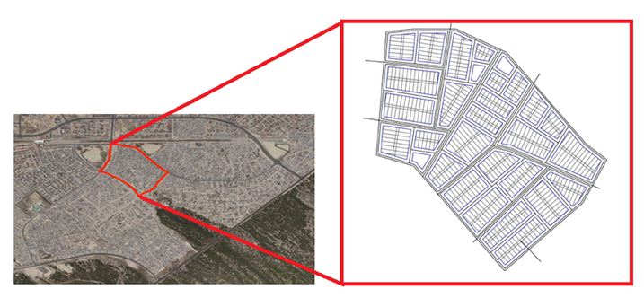
The case study area is Enkanini in Cape Town City, South Africa, for which we generate urban planning variants in a fast and interactive way.
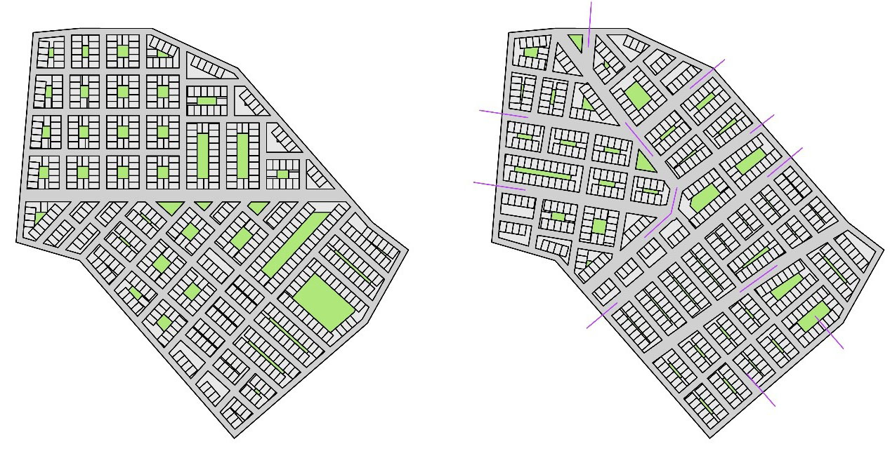
Example of two urban layouts for the sliced parcels, generated freely (left) and using initial street segments to guide street network generation (right).
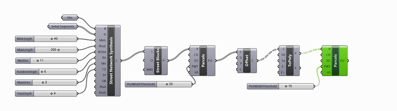
To increase the precision for generating parcels with a defined width, we nested the block and parcel generation.

Using the Speckle plug-in for Grasshopper the generated urban layouts can be made accessible online to share and communicate the design as well as to allow stakeholders to explore design alternatives. In accordance with the initial specifications, the interface allows to change the dimensions of the parcels within a defined parameter range using sliders to adjust the parcels width and depth.
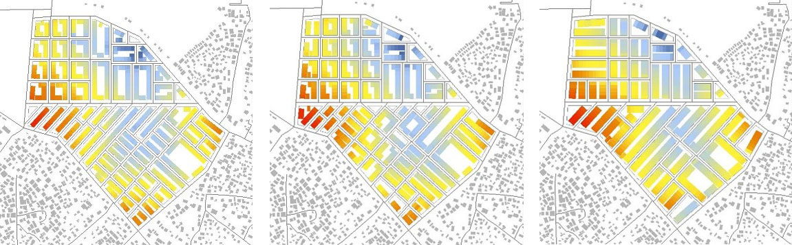
The generated urban layouts can be analysed with various methods. In this example we assessed pedestrian accessibility of the educational and commercial facilities by using a gravity-based method.
Video of the Computational Urban Design Process
Related Publications
Sorry, but the selected Zotpress account can't be found.
Hello? How to get a password for download Grasshopper Definitions, or get example code used in this video? Thanks.
Should be available soon.
Hi!
Can I have the password please? I need the definition
Thank you in advance
The download is available now!
Good morning, How could I get a password for download the definition because I can’t understand the example instructions of Toolbox content. I’am an architectural student of autonomous university of San Luis potosi, Mexico and I making my final project using new methods to get urban planning. Thank you
alexkilleman@alumnos.uaslp.edu.mx
Unfortunately, for now the download link is only accessible for members of the DeCodingSpaces-Toolbox group.
GOOD MORNING REINHARD, CURRENTLY I’M WORKING AT A HOUSING DEVELOPING COMPANY, I HAVE BEEN TALKING WITH MY BOSS ABOUT HOW WE CAN APPLY YOUR TOOLBOX IN THE INTERPRISE AND WE ARE VERY INTERESTED ON YOUR TOOLBOX ”DECODING SPACES” HOW CAN WE BECOME MEMBERS OF THE DECODING SPACES TOOLBOX GROUP?. WE COULD USE OUR HOUSING PROJECTS AS EXAMPLES OF YOUR TOOLBOX APPLIED IN A REAL LIFE PROJECT.
WHAT DO YOU THINK?
REGARDS
Dear Alejandro,
many thanks for your interest in our DeCodingSpaces-Toolbox and your request. To become a member of the group is only possible if you actively contribute to the development of the toolbox. We share the tools for free and open source with others as you may have seen. So you could use the tools as you like.
If you are interested in some specific applications, we offer various services via various institutions (AIT, FCL, Bauhaus-University, DeCodingSpaces company). If you are interested in such a service, please write me an email an we can discuss the details https://www.uni-weimar.de/de/architektur-und-urbanistik/professuren/computational-architecture/team/
Best regards
Reinhard
This is absolutely fantastic. I am a Rwandan urban planner and university lecturer and would like to duplicate similar project in one of the many informal settlements in Kigali, the capital of Rwanda. Can you kindly advise on the best way to learn and apply this computational urban design ? probably need the password as well.
Dear Alexis,
many thanks for your interest. We offer related courses on our online teaching platform https://otp.uni-weimar.de/
From October there will be more open courses.
For commercial applications, please send me an email to reinhard.koenig@ait.ac.at
Best regards
Reinhard
Dear Reinhard ,
thanks for the tool , it will surely help for my work , by the way ,does the teaching platform includes a complete course dedicated to this tool ? can’t really seem to find one , but mostly that talks in general about urban planning and evol.techniques .
Thank you very much
Dear Lola,
there is no single course on the OTP that introduces the DeCodingSpaces Toolbox. Since the components of the toolbox are very diverse, there are various courses focussing on different aspects. Not all of them are publically available yet. But we should change this for the next semester.
Best regards
Reinhard
Dear Reinhard ,
Thank you for your answer.
I found the subject very intresting and I’m actually waiting for an admin acceptance for my registration in OTP.I look forward to watch the courses or buy them if they are premuim and when there will be available.
I also found the tutorials and examples here very good for someone learning so thank you for all your shares.
Best regards,
Hi, it looks like the download for the grasshopper definition you so kindly provided does not work. I would love to have a look at your tool box an especially this definition, it looks super promising 🙂